GPS Data Collection
In most recent DHS surveys, the groupings of households that participated in the survey, known as clusters, are geo referenced. These survey cluster coordinates are collected in the field using GPS receivers, usually during the survey sample listing process. In general, the GPS readings for most clusters are accurate to less than 15 meters. Additional GPS data collection information is available in the GPS data collection manual.
In order to ensure that respondent confidentiality is maintained, we randomly displace the GPS latitude/longitude positions for all surveys, including those that do not have HIV testing. The displacement is randomly carried out so that:
- Urban clusters contain a minimum of 0 and a maximum of 2 kilometers of error.
- Rural clusters contain a minimum of 0 and a maximum of 5 kilometers of positional error with a further 1% of the rural clusters displaced a minimum of 0 and a maximum of 10 kilometers.
The displacement is restricted so that the points stay within the country and within the DHS survey region. In surveys released since 2009 the displacement is restricted to the country's second administrative level where possible.
For clusters without GPS readings, other means are used to determine the coordinates. Coordinates may be extracted from a paper map or a gazetteer of settlement names. For some surveys, cluster coordinates are extracted from preexisting census data provided by the country's census agency/ministry. Regardless of the source, all collected coordinates are always checked for accuracy before they are displaced and then released to the public. The source of the coordinates (GPS, map, gazetteer) is reported in the geographic data file that is released to the public. The DHS GPS data format provides detailed information about what information is available in each publicly-released geographic data file.
How to Access GPS Data
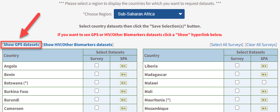
To access the GPS datasets published by The DHS Program, you will need to create an account as described on the Access Instructions page. Once you log into your account and create a new project and you choose a region, click on the option to Show GPS Data (which is identified in the screenshot below).

When the Show GPS Data option is toggled, you will be able to select GPS datasets for the country of interest. After you submit a request, it will be reviewed by The DHS Program. To fulfill our ethical obligation to survey respondents and our sponsoring agency, we must know how the geographic data in these files will be used before authorizing its distribution.
Download Documents
Guidance on how to use Geographic Information

A Field Guide to GPS Data Collection
DHS GPS Data Format (pdf, 64 KB)
Resources